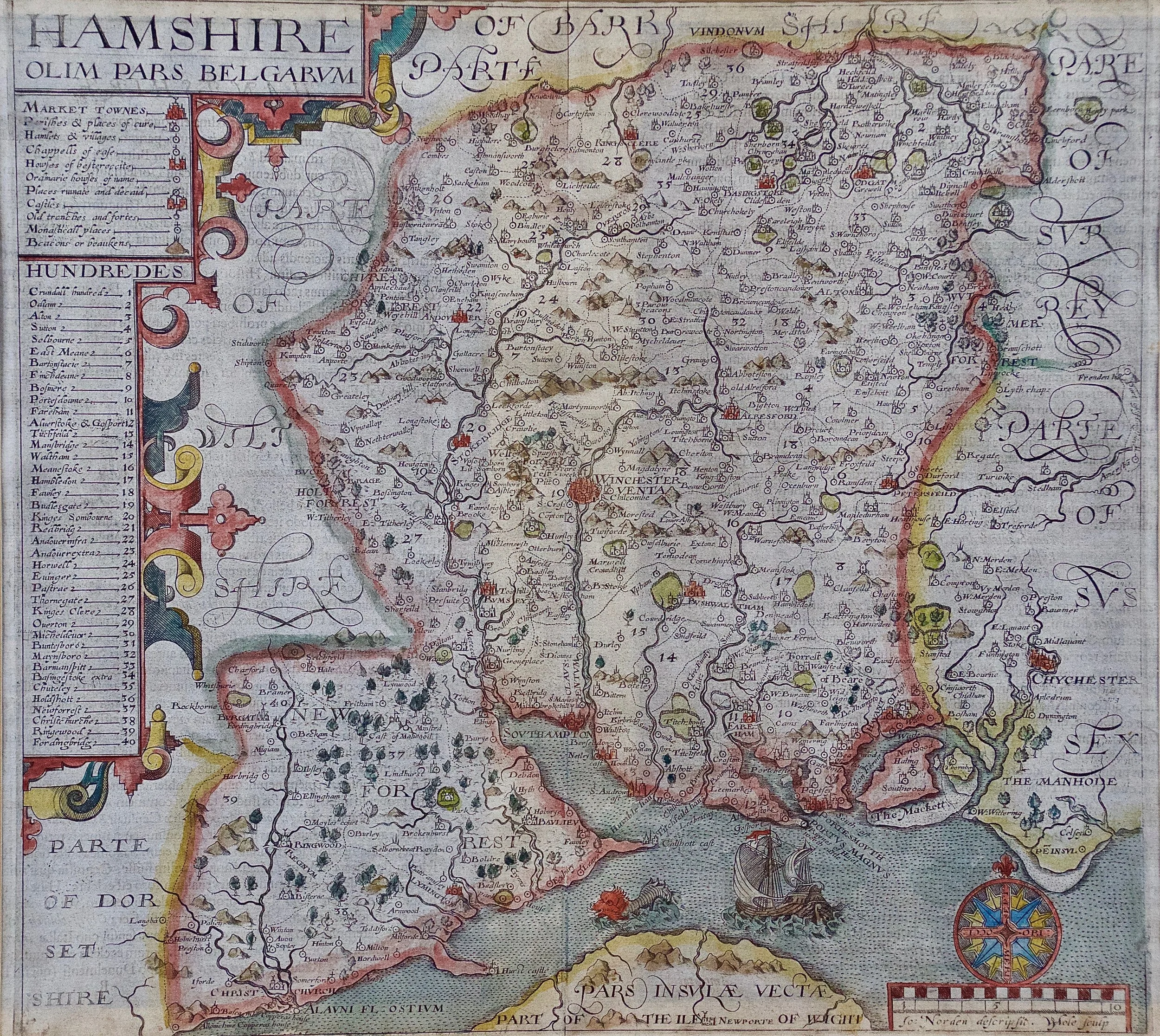
Skip to Content
Timeless Intaglio: Rare Prints, Maps & Books
Shop
All Listings
Antiquarian Prints
Antiquarian Maps
Antiquarian Books
Artists
Our Story
Previews
Contact
Login Account
0
0
Search
Timeless Intaglio: Rare Prints, Maps & Books
Shop
All Listings
Antiquarian Prints
Antiquarian Maps
Antiquarian Books
Artists
Our Story
Previews
Contact
Login Account
0
0
Search
Folder: Shop
Back
All Listings
Antiquarian Prints
Antiquarian Maps
Antiquarian Books
Artists
Our Story
Previews
Contact
Login Account
Search
Shop Hampshire County, Britain/England: A Map from Camden's" Britannia" in 1607
3927 Kip Hamshire olim pars Belgarum.jpg Image 1 of 10
3927 Kip Hamshire olim pars Belgarum.jpg
3927A Kip Hamshire olim pars Belgarum.jpg Image 2 of 10
3927A Kip Hamshire olim pars Belgarum.jpg
3927B Kip Hamshire olim pars Belgarum.jpg Image 3 of 10
3927B Kip Hamshire olim pars Belgarum.jpg
3927C Kip Hamshire olim pars Belgarum.jpg Image 4 of 10
3927C Kip Hamshire olim pars Belgarum.jpg
3927D Kip Hamshire olim pars Belgarum.jpg Image 5 of 10
3927D Kip Hamshire olim pars Belgarum.jpg
3927E Kip Hamshire olim pars Belgarum.jpg Image 6 of 10
3927E Kip Hamshire olim pars Belgarum.jpg
3927F Kip Hamshire olim pars Belgarum.jpg Image 7 of 10
3927F Kip Hamshire olim pars Belgarum.jpg
3927G Kip Hamshire olim pars Belgarum.jpg Image 8 of 10
3927G Kip Hamshire olim pars Belgarum.jpg
3927H Kip Hamshire olim pars Belgarum.jpg Image 9 of 10
3927H Kip Hamshire olim pars Belgarum.jpg
3927I Kip Hamshire olim pars Belgarum.jpg Image 10 of 10
3927I Kip Hamshire olim pars Belgarum.jpg
3927 Kip Hamshire olim pars Belgarum.jpg
3927A Kip Hamshire olim pars Belgarum.jpg
3927B Kip Hamshire olim pars Belgarum.jpg
3927C Kip Hamshire olim pars Belgarum.jpg
3927D Kip Hamshire olim pars Belgarum.jpg
3927E Kip Hamshire olim pars Belgarum.jpg
3927F Kip Hamshire olim pars Belgarum.jpg
3927G Kip Hamshire olim pars Belgarum.jpg
3927H Kip Hamshire olim pars Belgarum.jpg
3927I Kip Hamshire olim pars Belgarum.jpg

Hampshire County, Britain/England: A Map from Camden's" Britannia" in 1607

$1,475.00
Sold

An early hand-colored map of Britain's Hampshire county, published in the 1607 edition of William Camden's great historical description of the British Isles, "Britannia". This map was drawn by cartographer John Norden (c. 1547-1625) and engraved by William Hole (active 1607-1624) and William Kip (c.1585–1618). Although Camden's "Britannia". Was originally published in 1586, the 1607 version was the first to include British county maps, such as this one. This map includes text on the verso in Latin and no plate number, which is unique and only found on the 1607 version, as later versions had a plate number and did not have Latin text.

Creator: John Norden (Artist)

Creation Year: 1607 (manufactured)

Dimensions: Height: 17.13 in (43.52 cm) Width: 18.75 in (47.63 cm) Depth: 0.88 in (2.24 cm)

Medium: Engraving

Condition: See description below.

Add To Cart

An early hand-colored map of Britain's Hampshire county, published in the 1607 edition of William Camden's great historical description of the British Isles, "Britannia". This map was drawn by cartographer John Norden (c. 1547-1625) and engraved by William Hole (active 1607-1624) and William Kip (c.1585–1618). Although Camden's "Britannia". Was originally published in 1586, the 1607 version was the first to include British county maps, such as this one. This map includes text on the verso in Latin and no plate number, which is unique and only found on the 1607 version, as later versions had a plate number and did not have Latin text.

Creator: John Norden (Artist)

Creation Year: 1607 (manufactured)

Dimensions: Height: 17.13 in (43.52 cm) Width: 18.75 in (47.63 cm) Depth: 0.88 in (2.24 cm)

Medium: Engraving

Condition: See description below.

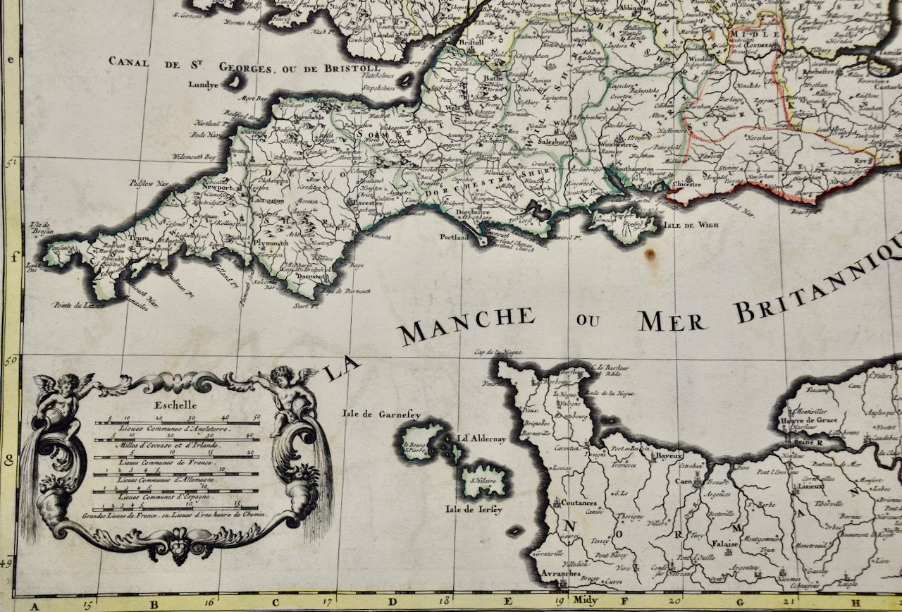
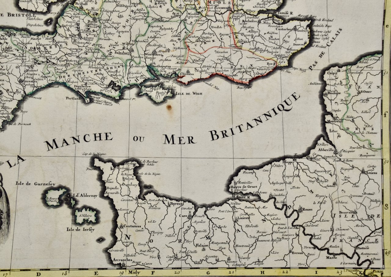
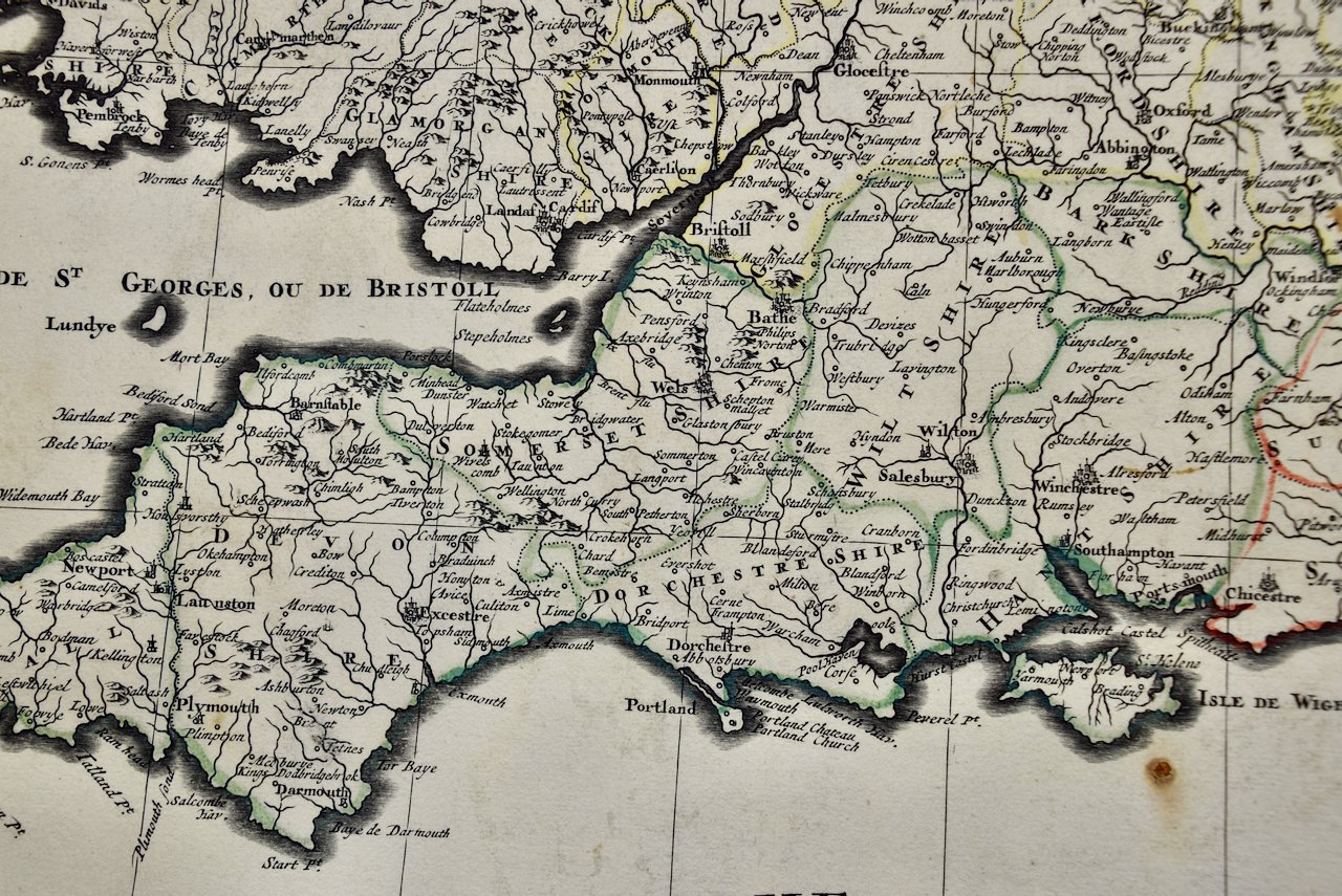
This attractive hand colored map of Hampshire County, England includes a colorful compass rose in the lower right corner above the names of the cartographer, John Norden and one of the engravers, William Hole. A sailing ship and a sea monster are seen in the English Channel. A list of towns is present in the upper left. The towns of Winchester and Southampton are shown on the map, as is part of the Isle of Wight.

The map is presented in a gold-colored wood frame with black trim and a cream-colored French mat. It is glazed front and back, allowing a view of the Latin text on the verso. The map is in excellent condition.

Related Works

Large 17th Century Hand Colored Map of England and the British Isles by de Wit 4395A de Wit, Accuratissima Angliæ Regni.jpg 4395B de Wit, Accuratissima Angliæ Regni.jpg 4395C de Wit, Accuratissima Angliæ Regni.jpg 4395D de Wit, Accuratissima Angliæ Regni.jpg 4395E de Wit, Accuratissima Angliæ Regni.jpg 4395F de Wit, Accuratissima Angliæ Regni.jpg 4395G de Wit, Accuratissima Angliæ Regni.jpg 4395H de Wit, Accuratissima Angliæ Regni.jpg 4395I de Wit, Accuratissima Angliæ Regni.jpg 4395J de Wit, Accuratissima Angliæ Regni.jpg
Large 17th Century Hand Colored Map of England and the British Isles by de Wit
$1,175.00
4753 Sanson & Jaillot, Le Royaume D Angleterre.jpeg 4753 Sanson & Jaillot, Le Royaume D Angleterre.jpeg 4753 Sanson & Jaillot, Le Royaume D Angleterre.jpeg 4753 Sanson & Jaillot, Le Royaume D Angleterre.jpeg 4753 Sanson & Jaillot, Le Royaume D Angleterre.jpeg 4753 Sanson & Jaillot, Le Royaume D Angleterre.jpeg 4753 Sanson & Jaillot, Le Royaume D Angleterre.jpeg 4753 Sanson & Jaillot, Le Royaume D Angleterre.jpeg 4753 Sanson & Jaillot, Le Royaume D Angleterre.jpeg 4753 Sanson & Jaillot, Le Royaume D Angleterre.jpeg 4753 Sanson & Jaillot, Le Royaume D Angleterre.jpeg 4753 Sanson & Jaillot, Le Royaume D Angleterre.jpeg 4753 Sanson & Jaillot, Le Royaume D Angleterre.jpeg 4753 Sanson & Jaillot, Le Royaume D Angleterre.jpeg 4753 Sanson & Jaillot, Le Royaume D Angleterre.jpeg 4753 Sanson & Jaillot, Le Royaume D Angleterre.jpeg
Great Britain, N. France: A Large 17th C. Hand-colored Map by Sanson and Jaillot 1693
$2,375.00

Prints
Maps
Books
Featured Items
Recent Acquisitions

Contact
Our Story
Sell Your Items
Subscribe to our newsletter!

FAQs
Terms and Conditions